
Upper Mamquam

I have found the Mamquam area an interesting spot to explore. There are a numerous of side roads with ample area to drive and sights to see that one  would need several days to explore the whole area. The upper part of the river valley has been intriguing me for some time and I tried twice earlier this year to see it but both times I got stopped short by snow. Today we saw none at road level.

Our day started with Geoff arriving at the house and helping me to reload the truck as it has been stripped down for some cargo transport earlier in the week and never reloaded. So that delayed our departure by 20 minutes but once moving we made good time to the Squamish area. We were a bit concerned as to how the traffic would be in heading up there as there was a huge music festival in Squamish over this week-end. But they all drove up yesterday it seems and left the roads clear for us.

Driving up the lower end of the road we had to use our commercial radio to call out position markers as the power project kept the road busy and we wanted to avoid any large equipment on the road. The power project also kept the first 13km in really good shape and so we made quick time to the project but once past it the road quickly deteriorated to the more standard potholed rough driving we have come to expect when driving out here. Even so, we made good time as we zipped up the valley. The place was quite deserted and we saw only one other person the whole day and he was camping at the side of the mainline.

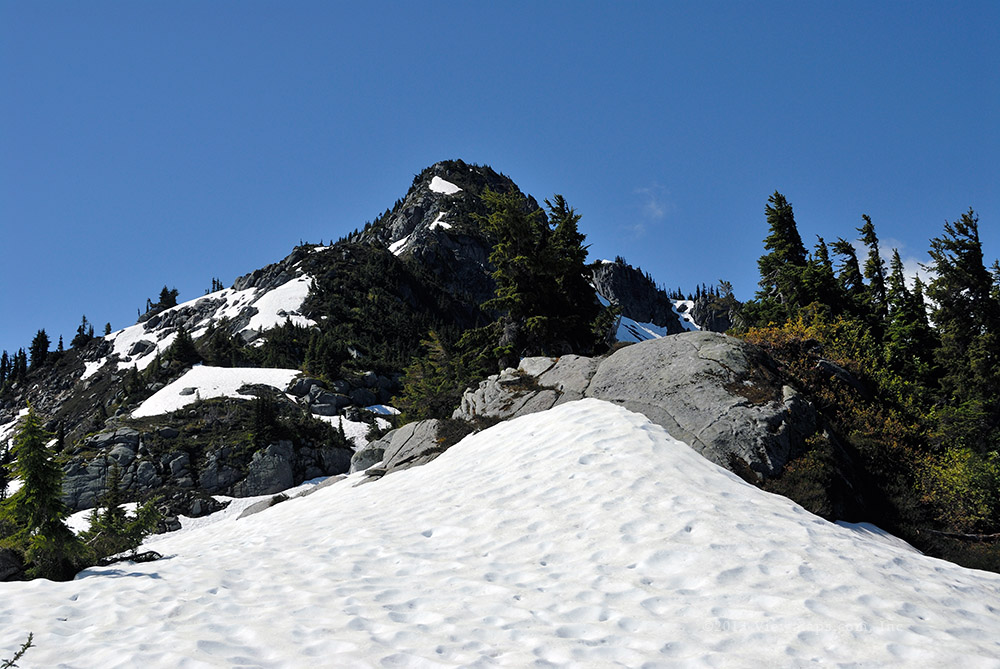
Our first destination was to take the side branch that climbed the slope alongside the upper Mamquam. The road is still used by hikers who drive to the highest spot so they can start a hike which climbs the slope to Seed Peak and even Mt Gillespie. We made good time to the top of the ridge but then encountered a narrow section where a clump of Alder was growing on the upslope side of the road narrowing the passage. After a bit of planning we pushed over the trees and continued to the end of the spur. Here we had some nice views across the Mamquam at Meslilloet Mountain. We also spotted some flagging tape marking the start of the trail to Seed Peak. Perhaps one day we can try it, it is around a 10km hike.

We then backtracked a short ways to a small pond on the ridge where Geoff spotted a well fatten rabbit. He went back for his rifle but was unable to find it again. Next we dropped down to a lower branch which traveled along the north slope of the Mamquam River. Here we came by the monument to a lost hiker where Ethan and I ate lunch last trip. We were able to make some good distance further down the road to its end. Along the stretch next to the monument the road is quite straight and level and provided a good spot for Geoff to try sighting in his scoped rifle. We staked out a 200 yard section and set up a small target, Geoff took a couple of shots but they didn’t hit the target. He will need to get a bigger one so he can find those that are just beyond the paper.

Done with this side of the river, we returned to the mainline and continued up, crossing over the Mamquam and then taking the branch the parallels the south slope of the river. Previously we started this road but stopped early as it seemed to be well overgrown. Today I had closely observed the road from the north side and felt it was worth pushing through the trees. So that we did and very quickly the road opened up and we had some clear travel for a few km’s before we were stopped by a serious washout rut travelling through the middle of a steep section of the road. We likely could have found a way past but we were satisfied with the distance we had made along this side of the river. We had also found a lovely pond along here that was surrounded by wild blueberries which made for some good photos. We backed up the road to just before it connects to the mainline and there we ate our lunch with a nice view of Mt Garibaldi to the north.

After lunch we continued up the mainline to the end of the road and then we drove a few more side roads on our way back. Here we thought back to the previous trip Geoff and I made to this area on October 7, 2011. Back then the weather was moving cloud around on us and we had times when we were engulfed by cloud. Today it was bright sun and the place seemed less alive but still it is a nice area. After completing a number of short spurs we came by one with a huge tree down across the road. There was a cut made out of the top half of the tree forming a path where an ATV could get over. This was just too tempting and so Geoff got out the chain saw and we proceeded to cut through the tree and haul it out of the way. After a bit of work we finally had the gap opened up enough and we drove past. A bit further we had a second tree to drag off the road. This one didn’t need any cutting. A bit further along we reached a group of fallen trees with a washed out road just beyond, now this was the end of the road for us.

We felt it was a good adventure so far and so we turned back and made our way out and back home without further incident. A pleasant outing and one in which I finally made it to the end of the Mamquam valley and roads.

Hiking Mount Agassiz

O ur morning began at 8:00 AM when Ralph and Brett arrived at my house in preparation to set off for our hike to the summit of Mount Agassiz. Although it was a pleasant morning it wouldn’t be a good start without a stop at the local Starbucks. And so we made our way to Brookswood and quickly had our favorite caffeinated beverages in hand. Our next stop was for gas and then before long we are at the start of the logging road on Mount Woodside.

I then switched the truck to four by four mode and locked the hubs. The road was actually in pretty good shape thanks to new construction taking place in preparation for some active logging later this year. Even so, the roughness of the road caught Brett quite off guard. About a third of the way up we encountered the first of several dump trucks coming down the hill. They were quite cooperative in allowing us to get past them but it still seemed to be a tight fit it times. Soon we reached an open gate and the active logging area. There we found a board where we signed in, then it was off to the place we had planned to start our hike. This final stretch of road went quite quickly, we saw quite a few side roads that had been improved and it looks like the area will offer some nice new access points once the logging is done.

It took us only a few minutes to get ready to start and then we were off on the initial slope climbing to the summit. Although it was a short hike, it was much steeper than we had expected. Fortunately being short, we weren’t too tired out by the time we finally reached the point marked on the maps as the summit. The summit was in from the edge and surrounded by trees which gave us no views to enjoy. So we moved a dozen meters to a ledge with a sharp drop that offered a nice view of the Fraser Valley and where we would have an enjoyable time operating.

With a lovely view and the warm sunshine we had found the spot for the day. It didn’t take long for Brett to have his inverted V antenna set up and making contacts across North America.  We also were chatting with other club members on two meters with Ralph’s Yagi. After a couple of hours of operating we had made around 18 contacts. This was now a successful activation of the peak for summits on the air. Having successfully achieved the activation, we decided to pack up before we got too hot and tired. The return hike went quickly and soon we were closing in on the truck but in looking back up the slope, Ralph was nowhere to be seen, and he wasn’t answering our calls. Finally we did reach him on a handheld radio and discovered that he was too far down the slope and to the right of the truck. After giving him new directions on the way back, Brett and I finished the hike to the truck and waited for Ralph to arrive. Soon we heard him crashing through the brush as he climbed up to the road.

Now that we’re all together again we set off for the return trip home. The drive down the mountain went without incident though we had to wait for a logging crew to unlock the previously open gate. Soon we were back on pavement heading home. The day was a success and we all felt we had a good day and enjoyed ourselves on the summit of Mount Agassiz.

Hiking Mt. Hansen

Last August Geoff and I attempted to reach the summit of Hansen. It was our first hike where there was no marked trail. On that occasion we had the misfortune of scheduling our hike for one of the hottest days of the summer. It didn’t play out as planned as the heat slowed us down and we cut across the sub-peak too early which led us into more difficult terrain. So we reluctantly abandoned our attempt at around the 85% point. But we planned a return the following summer taking what we had learned and applying to the new attempt.

Today was our day for the hike. We left the house at 6:30AM which got us to the start of the trail around 9am – not super early but early enough to benefit from the cooler air of the morning. The drive up the slope went very nicely with the tuned up truck, heading out we weren’t sure it would. Our last trip saw the truck struggling to pull itself up the slopes and we had to skip a number of side roads due to its performance. New plugs and a few other parts got the truck back into great shape and we flew up the slopes with ease.

This time we parked along the road near the place the road crosses the ridge line and hiked the ridge rather than from the end of the road but at a lower point. We made excellent time through the forested section. Being a month earlier in the season, the ground was still much wetter than last year and we came by a number of ponds and snow patches as we made our way along the ridge. Soon we reached the last of the trees and were now out in the open sun climbing the steeper section of the ridge leading to the sub-peak. There was much more snow still hugging the ground which was nice as it kept the air a bit cooler for us. We were cautious of it though as were weren’t sure how stable it was.

Soon we came by the point along the ridge where we had turned off the ridge to cross below the sub-peak heading for the second ridge that connects the two peaks of Mt. Hansen. The way ahead got much steeper at this point which was why we turned aside, but today we knew to keep going and to turn off much higher up. We fought our way across some steep cliff sections and picked our way along the edge of the snow fields as we didn’t trust them. Soon we had reached the point where we had planned to cut across. It was here that we crossed coming back on our first trip.  Geoff was carefully considering the route but felt very uncomfortable with it as the route required crossing several steep snow fields where a slip could send one sliding for hundreds of meters – gaining speed as one went!

After a lengthy study we finally decided to continue up the ridge to the first peak as it avoided the snow fields and though steep and criss-crossed with a few dense thickets of trees, it was probably safer. So up we continued and then we reached the first peak. The views were nice and we stayed for a few minutes to regain our breath before starting down the second ridge to the true summit. Here we were able to test out some snow fields in a safer way and found them to be more solid than first thought.

Heading down the ridge to the saddle went quickly and once at the lowest point we stopped to reflect on our prior trip as it was here where we turned back. A moments thought was all that was worth and now we were on our way up the final section of the hike to the true summit. This section actually seemed longer than I was expecting as we kept seeing shoulders and cornices that teased us into thinking we were most to the summit. But eventually we achieved the summit and were able to get a longer rest and eat our lunch. From here we could see up the Silver-Skagit valley and we were also able to look down on Eaton Lake on the far side of the valley.  Well one can’t stay at the top of the world for too long, soon we had to start the long trek back to the truck. Heading down is always faster for me and I wasn’t doing too badly keeping up to Geoff but then we had to climb the ridge back up to the sub-peak and that was slow going again.

On our trip down we travelled across the snow fields much more than on the way up as we had come to trust them a bit more and if we stayed back from the edge next to the big drop, it could save us time in getting back. Though we had some tiny slides, it went quite well crossing on the snow, and it was definitely cooler walking on them now that we were in the hottest part of the day. The constant breeze was also a welcome part of the day. Once into the forested section Geoff was constantly watching his GPS to keep to the trail we had made coming out. He did really quite well at following the path and soon we were at the logging road making our way the final way along the easier smooth surface.

The hike was tiring and challenging in places where we were crossing talus with steep drops around us and a couple of difficult points where we had to push through some dense trees on a steep slope. We felt good at being able to find a workable path along ridge lines and forests to reach our goals. I do feel much more comfortable now at being able to hike other summits with no trail markings and so I am looking forward to our second hike this summer which also has no marked trail to follow.

Bowen Island

Whis was my first trip to Bowen Island and I wasn’t sure what to expect. From all the reports I have heard from people with cabins on the island I was expecting a minimally developed lightly inhabited area. Instead I found a busy community with much of the usable land occupied by homes, cabins, farms and commercial ventures. I did sense that the isolated aspect of the island led to a slower more casual lifestyle with a distinct rustic feel but with exclusive under-tones hidden just below the surface.

I toured the island with Ralph Webb who traveled with me to Nairn Falls a few weeks ago. We left the house at 8am and arrived in time for the 10am ferry. The short crossing was pleasant in the warm sunshine and the breeze from the movement made it quite pleasant to stand at the front of the ferry watching the trip across. We were met on the island by a work associate of Ralph’s – Dean and his wife – they live on the island operating a small farm selling various specialty items including honey from a number of hives that they recently expanded.

Dean took us to the first location – a lovely picnic area next to Snug Cove where we had just arrived via the ferry. The park area over-looks the ferry terminal and one could walk to it from the park. It was actually an almost ideal location for our event. While there we took the opportunity to follow a short hiking trail to the top of Dorman Point where we enjoyed a lovely eastern view looking back on Horseshoe bay and UBC. We then returned to the picnic area and checked it out more carefully before returning to the car for a drive across the island to the golf course on the SE corner. Here we ate lunch and thought through the direction of the small bays around here. In the end we felt they faced the wrong direction and that the first picnic area would be better.

We next drove to the NE corner of the island where a local Amateur lived – Tom - and we ascended his very steep and windy driveway up a cliff face to his home. He has a spectacular view across to the sea-to-sky highway and Horseshoe Bay. He also has some very large antennas stretched between trees high up the cliff face giving him some excellent reception. He offered the help of the few active amateurs on the island for our event. After a short visit admiring his view we returned to Snug Cove for our return trip on the ferry. It was a nice but short visit and I will need to return to have more time exploring the natural aspects of the island.

Sumallo River

Sunshine valley is a small collection of cabins and small vacation homes not far past the town of Hope and just before the start of Manning Park. I have driven past it many times on the way to the park or the Okanagan but only once – 4 years ago – did we take the time to explore the roads in behind the cabins. Last time here we had just purchased our new truck and it wasn’t fully equipped yet with a bush guard bumper and winch and we were rather lame in what we would do. Previously we were stopped by two water crossings across the Sumallo and so our explorations were limited to one side of the river. We were hoping to do better today.

Our drive out started fine but by the time we were on the freeway we noticed that the truck had a loss of power when accelerating particularly at slow speeds. It didn’t seem too severe so we decided to keep going. Before long we were descending the slope of the Hope Slide with the small collection of cabins in sight. The residential area was quite busy with people milling about and many atv’s meandering the roads and fields alike as they made their way somewhere. We did notice that some new recreational facilities had recently been built and there was now a store and many new spots for RV’s and even cabin rentals. The place is growing up and gaining people.

After a slow drive through the centre of the cabins we finally reached the end of pavement and our real adventure could begin. The road soon crosses over the Sumallo River and there we noticed that the flow was quite strong and lifted some spray into the air for a nice looking photo op. Further along we came to the fork where one side leads back across the Sumallo but where the bridge was long gone. Drivers had created a water crossing just below where the bridge had been but the river seemed to be flowing just too fast for us to want to try the crossing. Perhaps if we had done it before we would have tried but not as a first time attempt. So once again we were going to be stuck to the one side of the valley. Perhaps if we come back in September we will be able to get across it.

We then took the branch up to the ski-hill. Last time we got as far as a locked gate but today the gate was unlocked and so we were able to continue along the road to the end where there is an old lodge that was once part of a ski facility. It was somewhat in poor shape but still usable for shelter. I don’t think it would take much to revitalize it. There was a family with ATV’s driving around the level area including some very small machines with little kids on them. I gathered a few photos but nothing all the spectacular here. So we backtracked past the gate - enduring some odd looks from the residents of the local cabins - and took another side road which led up the slope. Here we really had a rough time with the truck it was having extreme difficulty making itself up out of cross-ditches on the slope. We got quite concerned that we may get stuck up here. We did reach the end of this spur and I enjoyed some of the views looking back down on the road we had just driven to the lodge

We then returned back to the main ski-hill road and made our way back and came by another short spur which we took. It was along this side branch that I gathered some nice photos 4 years ago. We drove to the end of the road where we had to pull a large rock off the roadway. We could go only a short distance more as the road was washed out just before a lovely stream where I gathered some slow shutter photos. Here we ate lunch and once done we returned to the mainline and continued in.

Soon we were at the second washed out bridge across the Sumallo and here also the river looked just a bit too deep for us to try the crossing. So we continued up the mainline to the end where it crosses a much smaller stream on a broad level gravel bar. We stopped for more photos. The valley up here is actually very pretty and I would like to explore it in more detail somehow.

On our return we drove a couple of side branches, one we did previously the other was new to us. The truck seed to improve for a while and then struggle with the slow speeds. So we decided to not push it any further as it now seemed to be getting worse. It was mid-afternoon and though heading out now would be a little early, it was better than being stuck with engine issues. So we opted to head home before our luck ran out. The drive back went without incident and we got home early. Now I need to get the beast in for repair before I need it again in two weeks.

West Harrison Snow Ruts

I have been unable to get out much this fall thanks to the weather but today was a lovely sunny day and we felt we couldn’t pass up on the opportunity to get away from the crowds. We knew that the weather will have left deep snow on most roads by now and so we had to pick wisely otherwise our drive would be a short one, stopped by snow. We felt that the Sts’ailes (as the West Harrison is now called), would likely give us a good chance of finding enough open road to spend the day on. So we packed up and set off for the Coffee Shop. Once done with fueling up the body and the truck we made our way to the start of the FSR.

Traffic was light and we made good time, the start of the road looked promising and soon we were making our way up the initial section as the road made for the first view of Harrison Lake. As we had thought, there was snow piled up along the side of the road but it was plowed and we felt it would likely be so for a good distance. As we reached the first view of the lake we saw that the side road was rutted but the snow plowing made a rise with steep access to the side road. At first we felt we would walk it but Geoff soon felt it was easy enough to drive and so over the lip we went and splashed through an icy puddle. The road had a crusty layer of snow with a depth of around a foot on the main road area. We didn’t go far as the view I wanted was in just a short ways.

As I enjoyed the beauty of the lake and fresh snow on the peaks, Geoff looked over some heavy logging equipment that was parked alongside the road. Once I was done taking photos, we started back for the mainline, Geoff found a spot to turn-a-round but it was too deep in snow and we were starting to spin and dig ourselves into a hole. So he back tracked and looked for another spot which proved to be more solid and we were soon back on the main line heading north.

As we continued along we could see that the side roads were mostly buried in snow and would not be easy to travel, some were simply blocked by the deep piles of snow left from the plow. Our next stop was at the beaver pond which the mainline curves around. I gathered a few simple shots from the side of the road – not too adventurous today. Further along, we pulled into a short spur that offered us a few views of the lake. Here we heard some chain saw activity and after a short drive further up the mainline we came by some natives cutting up a fallen tree. As we continued north enjoying periodic views of the lake we noticed that the snow was getting deeper, the road narrower and the plow piles higher. It was now a one lane road with tall snow walls beside us – a bit inconvenient should a truck be coming towards us.

As we approached the Mystery Creek fork we came by a group of foresters working on their equipment alongside the road. They were making it hard to get past but with a bit of determination we were soon on our way up the road. We soon passed the Mystery Creek sign as we followed the clear path along not realizing that we just passed the fork, the mainline was not cleared and we didn’t even realize we had moved onto the Mystery Creek FSR. We continued west and stopped on a bridge where I got out to take a few photos of the frozen over creek. Here we ran into some ATV’s and a truck wanting to get past. Geoff pulled the truck forward and made room for them.

We continued up the Mystery Creek FSR and soon gained some elevation on the north side of the valley. Soon we came to a nice viewpoint where I got out to take photos. It was here that we met up with a caravan of 12+ jeeps trekking together. They unfortunately were coming down the road and it being one lane Geoff opted to back up a kilometer to a wide spot. Meanwhile I gathered a few photos. Geoff eventually made it back and we continued up the road the short distance further which was cleared. Here was a wide spot with some trailers that were occupied. We looked around briefly and then started back along the road. We decided to go to the fork and see if we could travel along the actual West Harrison. 
When we reached the fork we noticed some ruts heading out, but it looked deep and I didn’t think we could get far. Geoff wanted to give it a go but just as he was getting ready to move a pair of ATV’s came up the road and told us that the snow got very deep quickly and they got stuck only a short ways in and there was a tree down which we would need to clear to get even that far. We reluctantly decided to not try it. We started our drive back along the mainline past the loggers and started looking for a good side road to try.

We soon found one on the lake side of the road and there we came to the same two ATV’s who had stopped for a bit of lunch. We chatted for a bit and decided to eat our own lunch. While there a few jeeps came and went heading down the side road we were on which led down the slope to the lake. Once we finished lunch we decided we would also try the road but we soon discovered that we weren’t going anywhere – our hot tires had melted the snow where we were parked and now we couldn’t move. We were about to hook up the winch when another jeep came by and offered to give us a pull which we accepted.

We then set off down the road it was steep, snow covered, icy and extremely rough. We probably shouldn’t have tried it. But others had and we thought it would be fine. Unfortunately, not far from the bottom we encountered an extremely rough washed out section that was just too much for our long wheelbase. So we turned around and started up. It was as we cleared the worst of the challenges that we remembered that we had a broken leaf spring and should be taking things easy. We quickly got out to see if the spring was twisted but it looked fine and so we continued up. Soon we came to a steep water crossing that had formed an ice patch which stopped us dead. So we had to winch ourselves passed the stream to where we could get some traction. Soon enough we were back on the mainline heading south.

The clouds had moved in a bit and the sun was getting low so we decided to head home. As we came to the Helmlock Valley FSR I noticed that side road looked drivable and might be clear enough to reach a viewpoint so we started up it. We didn’t get too far – the first switch back – but we did get a nice view of the lake. As Geoff turned around at the switch back we got stuck. We felt that it would be best to put on the chains and so we dug out around the tires and put on the chains. It was hard going as our hands were cold and not that nimble. Eventually the chains were in place and we resumed our turn-a-round. This time we were able to get turned and we started down the road, not far along Geoff looked out and one of the chains had twisted and we had to remove it, we decided to continue without it. Soon a second and then third chain followed suit and we finished the drive down the spur with a single chain in place. We hadn’t put the rubber tensioners in place and so the chains were slipping. But we were soon back on the clear mainline and we set off for the start of the Fsr. The short remaining distance went without surprises and once at the end we checked over the springs – they still looked fine and so we left for home after a stop in Abbotsford for an end of day coffee.

Chilliwack River and Area

I was looking forward to a relaxing day in the sunshine alongside the Chilliwack Lake. It was also the annual BC wide radio contest and I thought I could participate in that while enjoying the scenery of the lake and gather a few photos while there. So Ethan and set off for the lake at the regular time this morning stopping of course for a shot of caffeine along the way.

The drive to the lake was fast and without incident but as we approached the lake we noticed the snow piling up alongside the road. By the end of the pavement we noticed that the gravel road was not plowed and though there were some tread marks leading over a pile of snow blocking the start of the road, it looked a bit ominous. So we opted for ease of deployment and put on the truck snow chains while on the packed snow.
Chains in place, we drove up and over the snow berm and followed the ruts. The snow was deep and crusty and we were slipping a bit but not too much so we continued on. At the three quarter kilometer point we bottomed out and now we were spinning our tires! Not a great start to the drive and the deep initial valley was still before us. We noticed that the ruts only went a short distance further to where an access road branches off. Well we were stuck so we hooked up the winch and pulled us forward and out of the hole our tires had dug. The snow was just too deep and so we dejectedly decided to turn back before we got stuck again.

Once back to the pavement we removed the chains and drove back a couple klicks to where we had seen a logged area with a short path plowed to the open section. We backed the truck in and there we set up the radio and antenna so I could work some contest stations. I could hear many on the east coast and actually worked a couple but the local ones were impossible to hear. After a couple hours we were getting cold and so we packed up the radio gear and started back down the road.

It was still early so we turned off onto the Foley Creek FSR and gathered a few photos of the Chilliwack River. We didn’t get very far here either, as the road was deeply rutted and we didn’t feel like putting on the chains again. After some photos were collected we zipped down the main road to the Tamihi FSR where we turned off to explore this area which was where I enjoyed some of my earliest adventures. The lower road was clear of snow and we made it several kilometers in along the creek to the first bridge. It was unfortunately blocked off by a barricade as the bridge railings had rotted off and though the bed was solid concrete and seemed stable, the powers to be felt it unsafe to drive. So we missed out on the majority of the road.

We back tracked to a major fork and took the upper branch which was soon buried in snow. We came by a pair of guys doing some serious target shooting and stopped to watch for a few moments. Then it was up the road as far as we could go before the snow stopped us. We got less than a kilometer as the road here was covered in ice and not worth driving. A short distance from where we stopped we had a lovely view of the Fraser Valley and I was able to gather a few more shots before we set off back to the start of the road and the final leg out. Once in Sardis I was feeling a bit deprived of caffeine so we made an emergency stop at the local Starbucks to fix up the situation. It was a gentle drive (by our standards) but still very enjoyable and though I didn’t get many photos I still felt the day was a success.

Harrison East and Talc Creek

It had been some time since we last did some serious snow shoe hiking and we felt it would be a good time to try it as the week-end promised some sun and dry weather. So Geoff and I picked the East Harrison area and hoped to hike the Cogburn FSR. When we set out in the morning we were already sensing that our plans were in trouble as the day was dull and overcast – not the best for snow shoe hiking. By the time we reached the Harrison area we were seeing low level clouds as well making it a damp dreary sort of day.

We started up the East Harrison and tuned in the 4x4 radio frequency we quickly heard a group on the radio and after chatting with them we learned that they were on the west side of the lake, so we wouldn’t be joining them. We drove up a number of kilometers and came by a clear spot with a view of the lake. While I was gathering a few shots Geoff heard water off on the opposite side of the road, he spotted a small waterfall and as we felt that we wouldn’t get to snow shoe we decided to bush whack through the underbrush and get to the stream for some photos.

The short hike wasn’t too difficult but the over-growth hid many logs and gaps and one had to be very cautious not to slip into a gap and possibly even break a leg. Once across the swampy lower area we arrived at the stream and found a fallen log which allowed us to cross to the far side where we were able to clear some brambles to open up the view of the small waterfall. It was a fun excursion and I did get a few decent shots of the stream from a few angles. Done with the stream, we returned to the truck while carefully picking our way through the fallen trees.

We continued up the mainline soon Geoff had the thought to give the Talc Creek FSR a try. The last time I was here a gate was locked right at the start of the FSR and we didn’t get to drive it. Today the gate was open and we sailed right through. The road climbs immediately past the gate and starts to follow upstream along Talc Creek. We made some distance along the creek as we slowly gained elevation but by around the 500m point we were stopped by deep snow. This could have been a spot to hike but by now the path forward was steep and Geoff wasn’t much in the mood with the dull weather. So we back-tracked and tried one of the side roads that we had passed on our way in.

This road followed along the Cogburn valley and being on a western slope it was clear of snow until close to 600m. By the time we turn back the snow was still passable but trees had fallen across the way and we could see that the snow depth was rapidly increasing and it wouldn’t be worth the effort to clear trees for a few hundred meters of road. Even so, earlier while Geoff was clearing some fallen trees he managed to fall and bruise his arm badly enough that I actually had to drive the truck for a while until his arm settled down.

We back-tracked to a level spot with a view of the Talc valley and there we stopped to enjoy our warm lunch. Geoff was able to start a small camp fire which gave more smoke than warmth but it was still a pleasant setting for a short stay. Done with lunch we continued back down the side road to the main Talc line and then took another side road which also followed the Cogburn valley but much lower on the slope. Here we soon encountered a large tree fallen across the road. Rather than cut it we decided to try out the new chain we had prepared and drag the tree. It took a few goes as branches kept snapping off under the strain. Once moved with drove up the side road and soon came by a huge moss covered rock.

The rock demanded our attention and so we parked and climbed up on it. The mosses were quite colourful and had many nice textures. I gathered a few images while Geoff explored the far side of the rock, he soon discovered that the far side had a sheer drop of 75 feet to the forest below! Being damp moss one had to be careful not to slip and go for an extended and fast trip to the trees below. We did make it back to the truck safely and as the rest of the road was not drivable we returned to the start of the Talc creek FSR and made our way to Cogburn Creek.

As expected, the Cogburn Creek FSR was gated at the start and as we realized earlier in the day the road at this elevation was quite bare of snow. So we took a few moments to explore the campsites below the main bridge over the creek before starting back down the mainline and our way out. As we drove south we tried the side road leading up Bear creek but found a locked gate before we got far. 

We decided to go back to where we had hiked to the small stream and take the road that led to the start of the stream and a small lake. To the north-east of the lake the road continues up a steep rise and one can walk out to a cliff face with a gorgeous view of the small lake and Harrison Lake beyond it. Here we stopped to enjoy the view and gather a few last photos before setting off for home. So even though our day was much different from our initial plans we found numerous interesting sites and had a decent time in the hills.

Squamish River Valley in the Winter

The last few trips we made were to the Harrison area and so we felt it was time to return to the Squamish region and renew our familiarity with the sights. The day was expected to be a sunny one which would give us great views of the snow-capped peaks and so we set off for the valley. This early in the season we weren’t expecting to gain much in elevation but we hoped the lower mainline would be clear of snow much like the east Harrison was. So we set off a bit earlier than normal and after the requisite stop for drugs at a Cloverdale Starbucks we made good time to Squamish where we fueled up and tried the local radio repeater. This was now our first disappointment – there was no response from the repeater!

We drove on to the start of the logging road and as we got close I put out a call to my Ham radio friend who lives at the home we were just passing. He responded and told us that the repeater was undergoing repairs and was working in reverse at the moment! I never did get it to respond but John said he would monitor the simplex frequency should we need him. So off we went to see how far we could drive. The road was quite clear at the start and we felt encouraged that we would get some distance in.

We didn’t make many stops as we drove in but we did take time at a wide area next to the river where we have stopped on most trips. By this point the snow was around a foot deep except on the mainline which was plowed! Geoff decided to try driving over the snow in this open and flat area but got only a truck length in before being stopped. It was just too wet and dense to drive. We backed out and then got out and walked to the river for a few photos. Walking was far more successful than driving. The sun offered some nice lighting effects on the far peaks and I was able to gather a number of photos.

Continuing on we drove as far as the B800 side road at which point the plowed road ended, it went up the B800 instead. Looking over the mainline it was obviously the same conditions that stopped us in 20 feet earlier and so we reluctantly concluded that reaching the Elaho would not be possible. So we decided to follow the cleared path up the 800. A short ways in an ATV came barrelling down which gave us some hope that we would find something of interest. 

Not very far in the plowing stopped where a swath of trees had wind-fallen across the road. We noticed that they had been recently cut but in such a way that there was an ATV wide gap down the middle of the road. Now we could have pulled a few trees out of the way but on reviewing the road past the trees it was clear that it was not plowed and we wouldn’t get far. So we turned-a-round and back-tracked along the mainline.

We came back to a waterfall that we ignored on the way in but now we stopped to gather some photos of it. Meanwhile Geoff set out for the river and did some target practice. Once done with the photos and the targets we continued our drive back and came by the B300 side road. It was clear and we decided to head on up. This was a new road for us and we were making some good distance along it. There was a further side branch that we took which climbed the slope and soon we were into a few inches of snow which made for a bit of slipping but the over-hanging trees were the bigger problem. So while Geoff drove I got out and cut down a few brush trees to clear the road. We made decent progress and got to a nice view point before the snow got too deep. It being lunch time and the view decent we decided to have our lunch right there. It was at this point I discovered I was missing my hat and that I no longer had protection from the glare. Once done with lunch we carefully backed down the road to where there was another fork that looked interesting. The side fork lead a short distance back to the slope edge where there was a wide flat area with a great view of the valley. It was a popular camping spot and a cemented fire pit had been built, it was quite huge.

Once done with the view we turned around and continued back down just before we reached the end of the section where we first had to clear some trees Geoff spotted my hat on the snow. So we were able to retrieve it after-all. It was unfortunately a bit wet to be worn at first. We returned to the Squamish mainline and a drove back to the B200 branch which we drove up, here we encountered some logging equipment parked along the side. We were able to get up past the spot I had found earlier with a great view of the valley but soon after we were stopped once again by snow. We had passed a truck that had unloaded a pair of snow mobiles which were somewhere up the slope.

Done with the 200 branch we back-tracked to the Ashlu and decided to drive up it. Unfortunately we got only a short distance past the power station before the road became deep with snow. So we reluctantly decided to head out. It was at this point that John called on the radio and invited in for a visit so we left the hills and made for his home – a measly kilometer from the start of the FSR. We had a great visit – he showed us his new quad-copter which he had just received earlier that week. He had it out flying earlier this morning and showed us the video he had captured with it. I was quite impressed with the quality of the gopro camera and the amazing angles he captured while flying the device. I think that one of these would give us some amazing video and be a great addition to our photos of the back-country. After spending an hour with John we resumed our trek home but not until we had refueled with another dose of drugs in Squamish.

Jones Lake on Ice

Wahleach Lake now commonly called Jones Lake is a great spot to enjoy some fresh air and views of the Cheam Range yet not very far away. I enjoy this area and the amazing view of Lady Peak, the bright sunny day would make the peaks look amazing so I felt it would be worth a try and see if we could get to the lake. This time of year the lake is high enough that it is often snowed in and not accessible. The day was just too nice to stay at home so off Ethan and I went for a shorter day that would start with our trying to reach the lake.

The initial section of road was clear and reasonably smooth but we gained elevation quickly and were soon passing clumps of snow alongside the road. We saw that the road was kept open via plowing and we were hopeful it would continue all the way to the lake. The piles of snow along the side of the road were several feet deep and it was obvious that we wouldn’t have had a chance if it wasn’t cleared. We met a couple of vehicles coming down but otherwise we were alone in the solitude of the snow and wilderness. 

Soon we were up to the start of the lake and the small recreation area at the north end of the lake. The plowed snow was piled so high that we actually missed seeing the entrance to the parking area, when we did finally notice it we were already passed it. The snow was piled deep enough that here was no way to drive into the parking area. So we continued to follow the cleared road past the cabins a couple of which seemed to be occupied. After passing the last one we continued up the road to where a small gorge crosses the road and here we had an amazing view of the Cheam Range. We parked the truck and got out to take photos. While I was gathering a few Ethan made his was over the crusty snow and down to the frozen lake. It was quite low and we were able to get down quite a distance before reaching the frozen surface.

Though the lake was frozen over, the layers of ice were not very strong as they were mainly refrozen snow layers but they were strong enough to allow us to walk out a short distance to a small stump. All this time I was gathering more photos of the peaks. They really were quite spectacular with the cover of snow. The sparkling snow crystals and black stumps strewn across the white snow field added an interesting foreground to the peaks. The short visit to the lake and walk across the bank was well worth the effort and we both found a number of sights that were quite interesting. Once we had explored the area below the gorge we returned to the truck to see how much further the cleared road went.

As we continued along we passed another parked truck, I noticed the occupants climbing back up the lake bank, they had been out there like ourselves. Even though they had likely been out there while we were I never noticed them, the area can be so vast that people just sink into it and disappear. We continued on a short way more but soon the cleared road ended. We looked at the road past the clear area and realized that it would be impossible for us to drive it. So we turned around and started down the road to the highway.

Once back to pavement we turned towards the town of Hope and then up the Fraser Canyon to the American Creek FSR. We missed it on our first pass but soon we were back on gravel and heading up the valley. We soon came by a guy under his car repairing something on it, but he looked like he was not in need of help so we continued on. The road had become quite muddy but still clear enough for us to drive and so we did. Finally we came by a fork the one path led up slope following the power lines. This fork looked a bit uninviting and seemed to be deteriorating quickly. So we backtracked and started down the other branch which led to a bridge across American Creek. When we reached the bridge we saw that the road ended just past the bridge. So we concluded that the other fork was the main way in but it now being lunch time we decided to stop on the bridge and eat lunch.

The wind had picked up and we found starting our burners took quite a few attempts but fortunately our soups were soon heating and we were able to enjoy a hot meal. Once done with lunch I gathered a few photos of the creek and then we turned back to the fork. Ethan wasn’t feeling the best so we decided to forego any tougher driving and head back to town. After picking up a coffee at the Blue Moose, I continued the driving and we set off for home. Though a shorter day, we did find some amazing views and we got to enjoy a couple spots that’s I had wanted to revisit.

Subscribe to 2013