
West Harrison

Today’s adventure actually began two weeks ago with an aborted attempt to explore the West Harrison. On that trip we started off well heading down the road looking for new things to enjoy. Our first side road led us into a small area just off the mainline where we looked over some fresh logging and found an old stump that had an interesting shape to it. Done with that we continued along the road looking down on Harrison Lake and saw Camp Cove off to the side. Here was a cove I had always wanted to explore but didn’t see how to get down to it. Two weeks ago we found a road that looked like it may go there and so we started down it, but we hit a bump which jarred our second battery causing it to arc and which then killed our alternator! So now we had to b-line it for home before our power ran out. We got almost home before the battery was dead and the truck wouldn’t move. Fortunately our second battery took us the rest of the way.

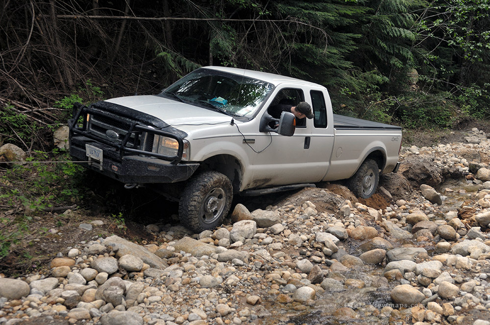
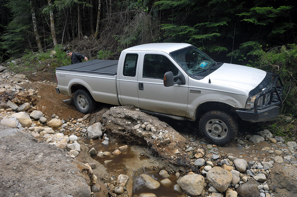
So here we are today and now we had to return to the side road and see where it went. We made fast time to the start of the road and began our drive down it. The first part was quite decent but slowly it got steeper, wetter and narrower but as it was heading straight down to the cove we had to keep going. Well it got to within 30 meters of the beach before it took a sharp turn across a small stream. Here it was only just wide enough for an ATV. In fact while we were there a pair of side-by-sides came down and just barely made it across the log bridge. We on the other hand now had to turn around as the road was too steep and slippery to back up over.

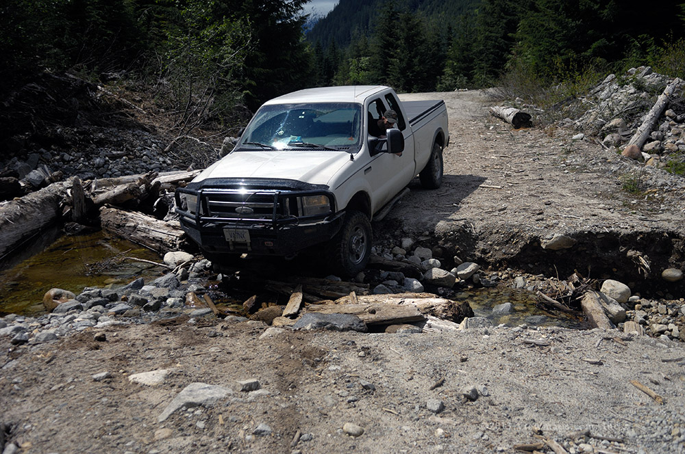
Turning around was an issue as the bottom of the road was only slightly wider than the narrow main portion and the sides were quite soft and dropped down a few meters. It didn’t look good as we were just too wide to turn around here but we had to. So our first task was to remove two trees that were hugging the side of the road so we could edge the front out over the side at that point. Once the trees were down we started the turn but soon got stuck on the low stump of one of those trees. So out came the winch to pull us a bit sideways and off of the stump. The winch also allowed us to back up over and down the far side of the road without fear of siding down so this gave us much more room to turn. After repositioning the winch we were successfully turned and ready to start up. 

Rather than leave, we decided as we were basically down to the cove we took some time to walk the final distance and check out the lake from water level. It was quite a dull day and drizzly so we took a few photos and returned to the truck to drive out. But the truck didn’t want to drive out. The road was just too slick for us to get traction so we had to pull ourselves up with the winch. In the end we had to position the winch in 6 different spots to get us back to safe road! Quite a morning but we got out and still had most of the day to explore with. But Geoff looked down and there we saw the battery light lit – our alternator was off again! So we decided to head back to the mainline and start back home.

We hadn’t eaten lunch yet so we decided to pull off at the last major side road with a lake view and there we looked over the electrical system. Now last time the problem ended up being a number of blown fuses so we looked for some today and eventually found it. Once replaced all was in good order and we felt very relieved. So we decided to explore this side road which followed the transmission line south. We found a level spot next to a tower with a good view of the lake and there we ate our lunch. Once done eating, Geoff set up a target and he took his first shots with his new scoped rifle. He did quite well with it but he still needs to properly align the scope.

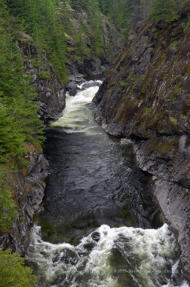
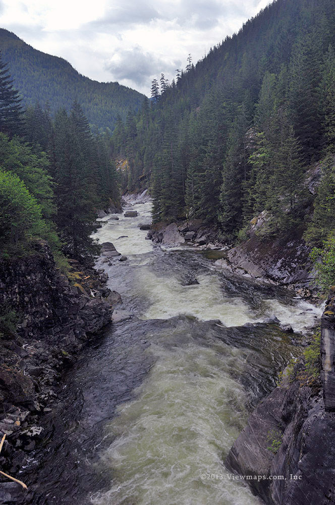
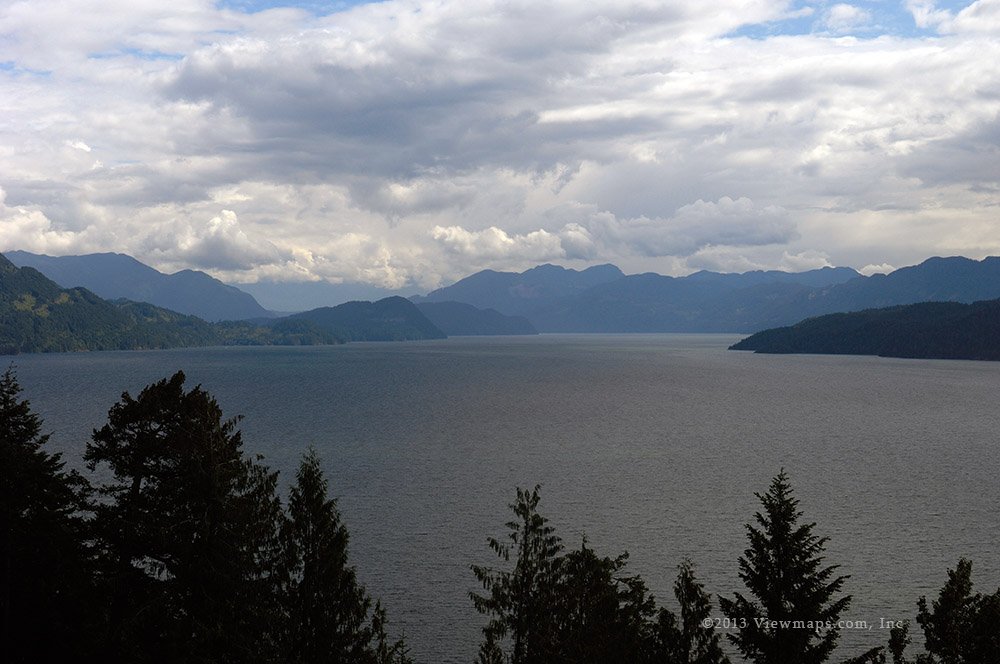
Done with target shooting, we continued south along the transmission line service road to the furthest point south and the last tower before the Harrison River. This spot has a steep cliff face where one can walk out to the top of to enjoy a great view of the river and Harrison Lake. It is one of my favorite sites and so I quite enjoyed our brief return to the spot. It was however the first time that Geoff was here. Done with the scenery we started back to the mainline stopping at a couple of places for a few more photos.

Though it was still a bit early we decided to head on out having had a full day of winching and thinking through a difficult extraction process. It felt great succeeding at getting out of our tight spot with virtually no false starts and a fairly straight forward plan. The winch was certainly essential today.

Mamquam

It is still early in the season this year and the upper roads are well buried in snow but the lower ones along the various rivers should be free to travel or so I thought would be the case with the Mamquam. I really quite enjoyed the far end of the valley and I hoped to get back there today. Alas the upper reaches of the river do gain some serious elevation and we were high enough to be stopped by snow well before the area I wanted to see. So I will need to return in late May.

The drive up the initial road section was surprisingly busy on the road radio frequency. It seemed that there was a fair amount of activity and we immediately started to wonder what was going on. As the announced vehicles passed they were all pickups and we didn’t encounter any heavy logging equipment so we were even more curious as to what was going on. Just past the bridge we took across the Mamquam we found out. There is a new Run-of-the-River project being constructed on the tributary to the Mamquam River – the Skookum Creek Project. It was well underway and workers were busy today.

Our road continued past the works area to the project but here the road took a serious drop in traffic and it was no longer a clear and open road. The heavy growth alongside the road was still folded over across the road from the recently departed snows and we had to weave our way through the trees and even chop a few out of the way. By the time we reached the Crawford Creek FSR branch the snow had started to appear on the road and we were able to go only a short distance further. So we grudgingly turned around and slowly drove back through the maze of trees, stopping in a few places for some photos.

Just past the power project but before the bridge we came across another side road which we decided to follow. This one connected to the Ring Creek FSR which joins the Garibaldi road across the valley. As we reached the rise above the power station we learned that this was the chosen path for the power wires from the station and the road was muddy but clear and so we followed along the newly constructed power poles. After a few kilometers we reached the end of the road. The road was deliberately blocked and the next power pole was serviced from the far end! Most annoying. It was a nice outlook next to the last tower and Ethan thought it was a good spot to do some archery and so he set up his target while I relaxed and took a few photos.

Done shooting we back tracked to the first set of poles we had come by and which were looking down on the generating plant below. Here we had a great view of the Mamquam valley and so we decided to eat lunch here. Once done with eating, Ethan did bit more target practice before we started out. He had found a nice disk shape log piece that he shot into. Unfortunately for him his grouping was too good and the arrows caused the wood to squeeze tightly around the arrows making it very hard to extract them. He did manage to get them out, after that he shot at an old canvas bag which we found next to the tower.

A pair of motor bikes zipped past while we were eating and then as we started down the road to the bridge we met up with two cyclists coming up the road. We said hi and quickly made our way down and to the bridge. The bridge was unfortunately blocked by a truck picking up discarded bridge timber. They finished the piece they were lifting before moving their truck out of the way. We decided to head back to the Indian River side road to see how far we could get along there but snow blocked us at the 5km point and so I didn’t have a chance to see the river where they took out a bridge to restrict access, perhaps next time. It was still too early to head out so we drove back up the mainline to the next side road and started up this branch. We actually got to over 700m thanks’ to it south-western exposure before being stopped by snow. The road continued further up the flank of Mt. Mulligan and I think it may prove to be a decent hike come summer. Well it was starting to get a bit later in the afternoon so we decided to head back to the mainline and out to the highway. But I felt like coffee so we took a short detour to Squamish to pick up some caffeine before the long trek home.

Sts’ailes

Today was to be our third attempt to reach the more northern portion of the road so when we arrived at the start of the FSR we planned to take very few stops until we got further up the road. The one feature of the area that we had forgotten about became apparent at the very start of the drive – dust. It had been dry for over a week and the road was now very dry and every vehicle traveling along it was kicking up huge dust clouds. When we started up the road we very quickly caught up to another driver who was following a second truck. Between them we couldn’t even see the road at times. This was a major concern for us as the dust was so thick we had to turn off the air-conditioner just to breathe.

As we continued up the road it became apparent that the driver was not going to let us pass and so we eventually got tired of following him and turned off on a short side spur to let the air clear. Here we found a few photo ops and took some time to enjoy the sunshine while the vehicles drove off and the dust cleared. Once refreshed we returned to the mainline to find the dust settled and now we could enjoy the drive. We soon came by the side road leading up the Walian Creek valley. This road was recently improved as logging was about to commence in the area. It made for a pleasant drive in and we got to a bridge over the creek but it wasn’t finished yet and so we could go no further. We drove a few of the side spurs and gathered some photos of Harrison Lake and the mountains along its east side. In the lower section we took a side road that led to a small lake. The road was very narrow and we were doing not too badly until a branch snagged the driver’s side mirror and ripped off the plastic covering! This was very annoying and we had to duct tape the piece back on as the plastic fasteners had been severed. Once calmed down, we decided we had to visit the small lake just below the road to make the loss worthwhile. The small lake was very scenic and would be a nice place to camp.

Once done with the Walian area we returned to the main line and continued north. As we drove north past the level of the small lake we noticed another side road leading in on the north side of the lake and we decided to drive in and see if we could reach the north–end of the lake. There we came by a pair of guys gathering some firewood but we spotted a side road leading south and we set off up it and soon came to a lovely Campsite over-looking the lake. Down on the shore of the lake was a small home built raft which was just too tempting for Geoff to ignore and he launched out into the lake for a short float. On our way out we noticed a couple foot bridges down below the raised road. They looked too tempting and so we decided to check them out. They followed a short trail to a small cabin! We looked over the cabin and saw that it would make a nice spot to rest in with a nice view from the end of the lake. So in the end this small lake was quite a nice treat and obviously thought well of by many others.

We seemed to be between most of the traffic now and we had little dust bothering us as we made our way north. Soon we came by the Mystery Creek fork. The area just before the fork has recently been logged and the slope is now bare, this is so different from previous trips that it took a moment to get our bearings. We could see a 4x4 group done the slope deciding their route, fortunately they decided to head up Mystery Creek and so our way along the mainline continued free of traffic. We zipped past the fork and were soon driving past the road to the 20 mile camp site. It was lunch time and I had suggested heading in there but Geoff wanted to do some target practice and the camp site wouldn’t accommodate that. So we continued north to doctor’s point.

A short distance before the point we came by a road leading down to the lake that looked quite drivable and we drove down it hoping for an area to eat lunch and do some shooting but when we got to lake level we found several groups already camping out enjoying the location. So we decided to head back up and continue north past the point and to the campsite we stop at the mouth of Bremner Creek. The road had gotten very rough and pot-holed by this point and it made the drive very irritating but we continued down to the campsite and when we arrived the best spot was taken by another group camping out! So once again we couldn’t do any shooting while we cooked lunch. But by now we were quite hungry and so we stayed and ate lunch after I gathered a few more photos.

Done with eating we decided to head back to the over-look at Doctor’s point which we had found on a previous trip. The access is a bit overgrown but we had no trouble getting to the nice flat area with a great view of the northern end of Harrison Lake. Here I gathered a number of lake photos along with some close-up flower photos. Meanwhile Geoff setup his target and started to shoot his new scoped rifle. He was doing quite well at a hundred yards. Once he had sighted in his scope a bit Geoff did some shooting with his other rifles while I used my binoculars on the far side of the lake. I was trying to figure out where they were planning to connect power to a run-of--the-river power project on the far side of the mountain ridge across the lake from me.

Once we were done with the site and we started for home. The pot-holes were even more annoying on the return as we were much more tired now but we eventually got past them and made our way south at a good pace. It seems that the other drivers were all off the main line as we encountered only one other driver and who was kind enough to let us pass him. So our return drive was mostly free of dust.

Big Silver and Shovel Creek

We planned our trip to include some serious driving into the furthest reaches of the East Harrison and to hopefully complete the loop to the Nahatlatch and Boston Bar. En-route we would look over the new run-of-river power projects on Big Silver and Shovel Creek. So though the weather was a bit questionable, we set off with high hopes of doing the loop.

We made good time to the start of the logging roads and soon we were zipping along listening to some 4x4ers on the radio from across the lake. There seemed to be very light traffic out today and so we made good time as we drove north, we did pass one small group of teen-agers heading up for the week-end as they were driving fairly slowly. It didn’t take long before we were stopped on the bridge high over the Big Silver River, the view of this gorge has always been a favourite of mine and I love coming back to enjoy the majesty and opportunity to capture a few images.

Done with the bridge we continued north looking for signs of the new power project but soon we reached the Shovel Creek fork and we turned up for the route to the Nahatlatch. We were disappointed in not seeing any signs of the new power project. Looking up info later confirmed that it had not been started yet. Our drive along Shovel Creek soon encountered a serious road washout. A small stream had eaten away at the centre of the road and it looked like it may stop us but Geoff surveyed the route and felt he could make it. I made sure he felt he could get back should we need to back-track later. The first section went quite smoothly but the last section was very narrow and the rear driver tire slide down in some soft sand and we were now in need of our winch.

The winch made quick work out of the situation and then we repositioned it so we could climb up the far side of the washout. The road then continued for a while before we encountered a second washout, this simply crossed the road and after moving a few rocks, it was a simpler feat to cross, though we did need the winch here as well. Finally we made some distance gaining elevation and soon we reached a 100m long snow pack that took us a second run at to get across. Not all that much further we came to a third creek washout, this one was just too deep for our long vehicle and so we grudgingly called it quits. I gathered a few photos of the up-stream portion of the creek as it was quite pretty tumbling down over large boulders. 

It being past noon we decided to take time to eat and so we enjoyed some nice warm lunch before continuing on down. Geoff wanted a spot to shoot his new scoped rifle but he wanted to sight it in over a 200 yard distance. Our lunch spot didn’t have the length so after eating we drove back the way we came and eventually found a long enough stretch of road. We set up a target on an old rotten log and then drove the 200 yards to where Geoff set up to shoot. He missed the target and couldn’t even see marks on the road to the side so he ran up to look but found nothing. A bit discouraged he tried another couple of shots but all missed the target and we couldn’t find any marks on the road. When Geoff turned back from looking at the road past the target he noticed 3 exit holes in the log just below the target! Geoff had shot remarkably straight, it was just low which is easily corrected by adjusting the scope. Next time he will be bang on. Now he was feeling much better about the target practice, if only he had noticed the first hole when he checked after the first shot.

We continued down the road to the smaller washout. We got most of the way across but got hung-up and so out came the winch again and we were soon over the gap. Just as we were reeling in the cable the first of 3 4x4’s came up to us. They were a group out to celebrate a bachelor party and were hoping to do the loop. They had shorter vehicles but no winch so I wasn’t sure they should be attempting the crossings. We left them there looking over that washout, I wonder if they did go on or just decide to enjoy the spot and camp there.

Then it was onto the first and longest washout. It was much easier this time as Geoff piloted the truck across the gap and down the south side of the gap but with all the traffic the road had gotten soft and soon the back passenger tire was sliding into soft sand. Rather than spin we opted to just attach the winch and pull ourselves out. The winch made very quick work of the final couple of meters and now we were rapidly descending to the East Harrison FSR along the Big Silver River.

I had hoped to take a side branch to explore the northern reaches of Mt Breakenridge but Geoff had to get back earlier today so we kept on heading out past the fork. A couple of km’s further we spotted a chap running up the road, well out of breath and waving us down. He desperately wanted a lift back a few km’s to campsite where some friends had a truck, his had broken down 6 kilometers further down the road. We took him back and then continued south and out. It was a decent day, though we didn’t get far up the Shovel Creek FSR we did have some challenges crossing the two washouts and then again on the way out. Hopefully the road will one day be opened up again.

Mamquam Again

I find the upper Mamquam valley an intriguing place to explore. The shape of the valley gives it a very lush and secluded feel to it and even though it seems so distant it is actually not that far off the pavement. It was for this reason I wanted to revisit the far end of the river system and rekindle my feel for the area. So Ethan and I set off for the valley at our usual time, early enough to have most of the good light in the hills but not early enough to require serious dedication. We made good time and soon were starting up the Mamquam FSR

The last time we came the road frequency was in constant use and so this trip I felt we should call out our locations as a proper courtesy to the others. There were a few other drivers on the road further up and we were able to monitor their progress to the power project. We made no stops along the road and we were soon beside the staging area for the project. I noticed that the lines were now strung on the towers we drove along last trip. Otherwise things looked as they had earlier.

We quickly passed the project and continued along the now much less travelled FSR. The road seemed in better condition than last trip, I guess the trees had greened up and gotten a bit more upright as they regained their strength. Soon we passed the furthest point of our previous trip with no snow in sight and so we continued along at a good clip. Eventually we came up to a group of campers whose vehicles were blocking our way. They mentioned that there was snow blocking access not much further along but we decided to continue in and see what we could.

It was a good thing we went on as the road was clear for quite some distance and we made to it a small pond and waterfall I had enjoyed the first time I was here. We stopped and gathered photos before continuing up the road. Not all that much further we did come to the snow and so we reluctantly turned back. We had passed two side roads in coming this far and so I felt we should give them a go. The first started down the south side of the upper Mamquam River. We didn’t go too far in as the road was getting quite overgrown and I didn’t feel like pushing it as the next side road gained some elevation and I quite enjoyed the views from it. So we returned to the mainline and drove to the next branch.

We started making some good elevation gain on the north side of the upper Mamquam. It being a south facing slope the snow was melted up to the 1130 meter point. But then we did get stopped by the snow and still short of the section I was hoping to see. I guess I will just need to come again quite soon. We backtracked down a few curves and started along another branch. This one maintained a rather level track up the valley. We soon came by a monument to a lost hiker who it would seem had been lost up here and his body never found. We drove a bit past the marker but soon came by snow and so we returned to the monument and there we ate some lunch.

Done with eating and enjoying the view of the valley, we back-tracked to the mainline and started on our way out. When we arrived at the camp spot, the atv’s and occupants were missing. They must have passed us while we were up the slope eating lunch. Further back to the start there was another fork which I hoped to explore as a possible alternate way out. So we continued on our way along the new road but soon we were driving through thick brush and I was not at all hopeful that this road would allow us to pass through. Sure enough it closed in some more and we eventually snapped off the whip on our commercial radio’s antenna! We stopped to fix that and once back to almost normal we decided to give up on this side road. It seems that we had finished viewing the accessible side roads and so we started on our way out. I wanted to check out the Stawamus/Indian valley to see if it was indeed blocked and so when we arrived at that fork we set off for the distance.

We made it within a kilometer of where there had been a strong fence stopping further access. That was annoying as we had got so close but neither of us felt like walking in and so we settled for a few photos of the tad-pole pond before we left for the highway. I guess I will just need to try it again mid-way through the summer.

Nairn Falls

Ralph had dropped in on Nairn Falls a number of years back and he wanted to go back and spend more time with his newer camera gear. He was also hoping for a few tips on getting better results from it as his photos seemed quite soft. I had never been to the falls so it was a worthy destination and I was quite looking forward to seeing the waterfall as they are of my favourite subjects. This would also give me a chance to test out the gas portion of my new electric car – a Chevy Volt. Virtually all of my driving is quite short and I had never used much gas in it so far, so this run of 400kms would give me a good feel of how it performs in mountain mode through the hills.

Ralph came by just before 8:30am as planned and we quickly set off for our first stop along the trip – the local Starbucks alongside our planned route! Ralph was already impressed with the quietness of the car and its beefy performance on the highway. With coffee in hand we continued on route to Pemberton, not stopping until we reached the parking lot in the park. There were quite a few people wandering around but still many spots to park and so we found a good location and got our gear loaded up for the 1.6km hike to the waterfall. The weather was dull with the odd misting but generally a pleasant temperature for walking outdoors.
We made good time along the dirt trail to the falls, and soon we were standing on the platform overlooking the waterfall, enjoying the roar of the heavy flow. It was an impressive sight with the high volume of freshet coming from the snow pack. We spent an hour at the site gathering photos from every angle we found interesting. It was quite popular with new groups coming and going continuously, all seemed suitably impressed with the power of the water.

Once we had our fill of the waterfall we returned to the car and drove into Pemberton for lunch. Here we found the local EV charging station where we plugged in for a few free kms of travel. We walked a couple blocks to a restaurant I had looked up earlier – The Wood Restaurant & Lounge – we both found the food to be quite good and worth coming back to when in the area. Done with lunch, we walked back to the car and saw that we had added a bit over 3KWhr charging or around 15kms. After topping up the gas tank with 20l we set off for Brandywine Falls. 

BrandyWine Falls is another park with good parking, facilities and an easy walk to a nice viewpoint of the waterfall. This waterfall is much higher than Nairn but one is further from the water and you don’t get a real sense of its power. Tthe view is still quite spectacular and we enjoyed gathering a few more photos. I did find the platform shake as people moved around on it so I had to take time waiting for moments when the other spectators were standing still. Done with that scene we continued on our way south and home. Of course as we entered Squamish we had the urge for another shot of caffeine and so we had a short side trip to pick up a cup of the hot stuff for the final leg of the drive. The whole drive went smoothly except for some slow traffic on the freeway from Willington to Brunette. The car used around 19 liters of gas for 400kms and the mountain mode gave lots of power for climbing the steep sections of the highway. All told the car performed very well and we couldn’t even tell when the gas engine would kick-in for a charge-up.

Subscribe to 2013